
The photograph you have seen a thousand times — elephants on a pale plain, Kilimanjaro blazing white behind them — tells you almost nothing about what an Amboseli elephant encounter actually is. The photograph shows scale and spectacle. What it cannot show is that the matriarch in the foreground has a name, a documented family history going back to 1972, and navigational knowledge of this landscape that her great-grandmother passed to her grandmother, who passed it to her mother, who passed it to her.
The photograph cannot show that the water her family is walking toward fell on Kilimanjaro decades ago and has been travelling underground ever since. What you experience at Amboseli is not wildlife observation. It is the reading of a family history that has been accumulating for fifty years.
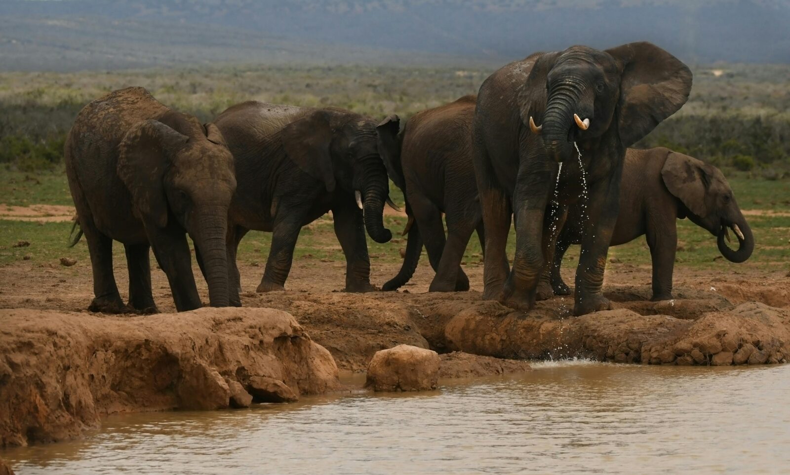
The number that changes every elephant encounter
In 1972, a young researcher named Cynthia Moss arrived in Amboseli National Park with a notebook, a camera, and the intention of documenting individual African elephants over an extended period. The Amboseli Elephant Research Project she founded that year has been running continuously for over fifty years, making it the longest-running study of any wild animal population on Earth. The database it has produced covers more than 3,000 elephants across multiple generations. Researchers can trace family lines from individuals alive today back to great-grandmothers observed in Moss’s first field seasons. Every adult in the current Amboseli population has a name, a documented family structure, and a behavioural record that may span decades.
This is not merely an academic achievement. It is the fact that transforms an Amboseli game drive from wildlife observation into something more like meeting a community whose history you have been briefly introduced to. When your guide points to the matriarch leading her family to the Enkongo Narok swamp in the early morning light and says “that is Echo’s granddaughter — she was born during the drought year, she lost two calves in 2016 but has successfully raised three since, and her family’s range extends to the Amboseli-Tsavo corridor” — you are not watching a generic elephant.
You are watching a specific individual whose life is documented, whose decisions affect the survival of twelve other elephants in her family, and whose navigational choices your guide can explain in terms of behaviour patterns accumulated over years of direct observation.
No other wildlife destination in Africa offers this depth of individual knowledge. The Mara’s lions are documented by some researchers but not with Amboseli’s comprehensiveness. Samburu’s elephants are studied but not at this temporal depth. Amboseli’s fifty-year research record is genuinely unique, and what it does to the quality of the wildlife encounter — the layering of specific individual history onto what would otherwise be a visually dramatic but intellectually thin observation — is the reason experienced safari travellers consistently rate Amboseli as among their most meaningful Kenya experiences.
Elephants at Amboseli SAFARI — ESSENTIAL FACTS
| Research project | Amboseli Elephant Research Project (AERP) — founded 1972, Dr. Cynthia Moss |
| Database depth | 3,000+ elephants, 50+ years continuous data — longest study of any wild animal population on Earth |
| Current population | ~1,800 elephants across the wider 8,000 km² Amboseli ecosystem |
| Park size | 392 km² national park · Elephants use 8,000 km² ecosystem seasonally |
| Best time for Kilimanjaro | January–February — driest air, clearest mountain visibility 6am–9am daily |
| Best time for elephant concentration | June–October dry season — herds at permanent swamps |
| Primary swamp | Enkongo Narok — largest, most productive, best photography access |
| Park fee (2026) | ~$60 per person per day · KWS eCitizen portal · Cashless only |
What fifty years of science revealed about elephants
The research conducted at Amboseli has produced findings that changed not just how scientists understand elephants but how humanity values them. Four discoveries stand out as having had the most significant impact on both conservation policy and public understanding.
Matriarch knowledge as life-or-death infrastructure
The most practically important finding concerns the relationship between a matriarch’s age and her family’s survival. Research documented that elephant groups led by older, more experienced matriarchs had significantly higher calf survival rates during drought years. The mechanism is spatial memory: older matriarchs carry decades of navigational knowledge — where distant water sources are located, which routes are viable in extreme drought, which areas have been dangerous in the past. When the obvious water runs dry, they lead their families to places they visited as calves, following memory pathways that younger matriarchs simply do not have.
The practical and deeply sobering implication of this finding is mathematical. When a matriarch is killed — by poaching, by drought, by human-wildlife conflict — the knowledge she carries does not transfer to her daughters. It is simply lost. The family’s probability of navigating the next drought successfully drops measurably. Research has documented specific family groups that declined significantly after the death of an experienced matriarch, compared to groups that maintained experienced leadership through the same drought conditions. Protecting a matriarch is not sentiment. It is protecting the navigational infrastructure of twelve or fifteen other lives.
This research also explains the concentration of elephant families at Amboseli during dry season from a different angle than simple thirst. The matriarchs know that the Enkongo Narok swamp is permanent water — they have been coming here for decades, led by mothers who knew before them. The morning parade of elephant families to the swamp is not instinct in the simple sense. It is the expression of accumulated specific knowledge, passed through maternal lines, about this specific place and its reliability.
Infrasound: the communication no one could hear
Early in the Amboseli project, researchers noticed something that defied easy explanation: elephant family groups approaching the same water source from different directions would sometimes adjust their routes or timing in ways that suggested coordination — but there was no audible communication between them. Cynthia Moss and her colleagues, working with acoustic biologist Katy Payne, investigated and found that elephants produce calls in the infrasonic range — frequencies below 20 hertz, the lower threshold of human hearing — that travel through both air and ground over distances exceeding a kilometre.
The ground-conducted component of infrasonic calls is particularly significant. Elephants can detect ground vibrations through their feet and through a fat pad in the forefoot that transmits vibrations to the ear. This means elephant communication has two channels simultaneously — air and ground — creating a network of information exchange that was entirely invisible to human observers before the research instruments to detect it existed. Two family groups converging on the same water source can exchange approach information and adjust accordingly. A family threatened by predators can broadcast distress signals that related groups can detect from distances far beyond visual or conventional auditory range.
The discovery transformed the interpretation of elephant social behaviour that had previously seemed mysterious or random. What looked like inexplicable shifts in direction, sudden coordinated movements, or apparently unmotivated groupings could now be understood as responses to a communication channel that researchers had simply lacked the instruments to observe. The Amboseli data contributed centrally to this discovery, and the research it enabled continues to develop. More recent work has documented that elephants can recognise the distinctive infrasonic “voices” of specific individuals — that a matriarch does not just hear an infrasonic call, she hears that this specific call is from her daughter’s family three kilometres away.
Mourning: grief as documented behaviour
Before the Amboseli research accumulated sufficient data, the question of whether elephants experienced anything resembling grief was philosophically contested and scientifically undocumented. The multi-decade observation record at Amboseli changed this. Researchers documented, across multiple instances and multiple family groups, a consistent behavioural pattern around deceased family members: elephants return repeatedly to the bones and skulls of deceased relatives, touching them with their trunks and feet, standing in extended stillness near the remains, showing physiological indicators of distress including temporal gland secretion and elevated cortisol levels.
This behaviour is not confined to the immediate post-death period. Elephants have been documented returning to the bones of family members years or even decades after death, responding differently to the remains of known individuals than to those of unknown elephants. The Amboseli database provided researchers with the ability to confirm that the elephants approaching and handling specific bones were indeed related to or known to the individual those bones had belonged to — a level of evidential precision that transformed what might have been an interesting anecdote into documented science.
The conservation implication is significant: mourning behaviour in elephants contributes to the scientific and legal case for treating them as sentient beings under wildlife protection law. Countries that have moved toward stronger legal protection for elephants have frequently cited this category of research in their legislative justifications. The database that made this research possible was built at Amboseli, using data that began accumulating in 1972.
DNA in ivory forensics: research that fights crime
The Amboseli population database has found a use that Cynthia Moss could not have anticipated when she began her field notebooks in 1972: it provides a reference population for the forensic analysis of confiscated ivory. When law enforcement agencies seize ivory — which may have been harvested anywhere across a wide geographic range — genetic analysis of the ivory can be compared against reference population databases to determine geographic origin. Knowing where poached ivory comes from is essential intelligence for targeting anti-poaching operations and prosecuting trafficking networks.
The Amboseli database is one of several that contribute to this forensic infrastructure. Its depth and geographic precision make it particularly valuable as a reference for ivory seized from the southern Kenya region. Every DNA sample from an Amboseli elephant makes the forensic database more precise. This is conservation science serving law enforcement in a direct and practical way — the fifty-year commitment to documenting individual elephants producing an outcome that was not foreseeable at the project’s beginning.
The underground water system — Kilimanjaro’s gift to the plain
The most important and least understood fact about Amboseli National Park is that its permanent water does not come from rain that falls within its boundaries. The swamps that sustain the park’s wildlife, concentrate its elephant herds, and produce the reflective foreground that makes the Kilimanjaro photograph possible are fed by water that fell on Mount Kilimanjaro — 40 kilometres south across the Tanzania border, rising 5,895 metres into the atmosphere.
The mechanism is volcanic hydrology. Kilimanjaro’s lower slopes are composed of highly porous basaltic and volcanic rock that absorbs precipitation and snowmelt efficiently. This water does not run off the mountain in surface streams — it percolates downward into the rock and then northward, underground, crossing the international border invisible beneath the Amboseli basin and emerging at the surface as the permanent springs and swamps that define the park’s ecology. The journey takes decades. Water currently emerging in the Enkongo Narok swamp fell on Kilimanjaro’s upper slopes as rain or snow approximately 20 to 40 years ago, depending on the specific pathway it took through the volcanic rock.
The ecological implication of this timeline is profound. The swamps are not responding to current rainfall patterns. They are a delayed, filtered expression of precipitation on a mountain that is 40 kilometres away, measured in decades rather than days. In a landscape where seasonal rains are unreliable and droughts are recurring, the permanence of the Amboseli swamps — guaranteed not by current conditions but by water that fell on Kilimanjaro a generation ago — is the ecological foundation on which everything else depends.
There is a shadow over this permanence. Kilimanjaro’s glaciers are retreating at a documented rate. The Furtwängler Glacier on the summit plateau has lost more than 80% of its area since the first measurement in 1912. No one can predict with certainty how or when reduced glacial input will affect the underground water system — the decades-long travel time through porous rock makes the relationship between surface hydrology and swamp output extremely difficult to model.
But the possibility that climate change on a volcanic mountain in Tanzania is working its way, underground and across a national border, toward eventual impact on a Kenyan national park is one of the more remarkable examples of cross-boundary ecological interdependence in Africa. Understanding it changes what the Amboseli swamps mean.
The Kilimanjaro photograph — how to actually get it
The image that defines Amboseli in the global imagination — elephants on the pale plain, Kilimanjaro white and massive behind them — is achievable. It requires understanding one specific meteorological fact: the mountain generates its own weather system, and the daily cycle of that weather system is the primary variable in whether you get the photograph or a grey sky.
Kilimanjaro sits at 5,895 metres. At that altitude, the mountain heats and cools on a different rhythm from the surrounding plains. As the day warms and convection currents develop, moisture is drawn upward from the lower slopes and condenses as cloud around the upper mountain — typically beginning around 9am and usually obscuring the summit by 10–11am. In the opposite direction: overnight cooling causes the upper atmosphere to stabilise, and the pre-dawn hours bring the clearest conditions of the day. The effective photography window at Amboseli is approximately 6am to 9am on most days, with the 6:30am to 8:30am window being the most consistently clear.
January and February produce the most reliable Kilimanjaro visibility of the year. Kenya’s short dry season brings the lowest atmospheric moisture content, and the combination of dry air, stable overnight conditions, and the gradual dawn reveal of the summit produces conditions where the mountain is photographable from ground level on the majority of mornings. The June through October dry season is generally good for Kilimanjaro photography but not as consistently clear as January–February — the longer dry period means more atmospheric dust, which reduces clarity and colour saturation.
Position at Enkongo Narok swamp north edge by 6:15am with Kilimanjaro to the south-southwest. Bracket exposures in the 6-9am window. Telephoto focal lengths (200-400mm equivalent) compress the scene so the mountain fills the upper frame and elephants occupy the lower third. Shoot RAW or ProRAW to recover both summit brightness and foreground detail in post-processing. Remain at position through the full window rather than returning to camp for breakfast.
Observation Hill — the only point inside Amboseli where visitors may leave their vehicle without an escort — provides a 360-degree panorama of both swamps and Kilimanjaro. A five-minute walk to the summit. Arrive before 6:30am for the best summit light.
The Kilimanjaro shot exists because of a specific meteorological window. January and February are the most reliable months. 6am to 9am is the daily window. Everything else — the elephants, the swamp, the composition — falls into place around those two facts.
The corridor problem — conservation’s unfinished work at Amboseli
Amboseli National Park covers 392 square kilometres. The Amboseli ecosystem — the area that the park’s 1,800 elephants actually use across the full seasonal cycle, following water and grazing — covers approximately 8,000 square kilometres. The difference between these two numbers is the central challenge of Amboseli’s conservation future.
The land between the park boundary and the wider ecosystem is Maasai group ranches and community conservancies: Selenkay, Elerai, Kimana, Tawi, Mbirikani, and others. Some of these have been brought into the wildlife economy through the conservancy model, receiving income from tourism in exchange for maintaining their land as wildlife-compatible habitat. Others are under growing pressure from agricultural expansion, population growth, and the collapse of the traditional Maasai pastoralist economy that historically maintained open grazing land compatible with wildlife movement.
The Kimana Corridor, linking Amboseli to the Chyulu Hills and Tsavo West ecosystem, has been under pressure from agricultural encroachment for years and has narrowed significantly. The Kitenden Corridor, essential for cross-border elephant movement between Amboseli and the Kilimanjaro Forest Reserve in Tanzania, narrows each year as farmland expands on both sides of the border. Without these corridors, the park’s elephants would eventually be genetically isolated — unable to access the full seasonal range they use across the year, unable to mix genes with other elephant populations, and increasingly dependent on a permanent water system whose long-term reliability is itself uncertain.
The community conservancy model is the primary mechanism currently working against this isolation. When Maasai landowners receive monthly income from tourism operations on their land, they have a direct economic incentive to maintain that land in a condition that generates tourism value — which means maintaining it as wildlife habitat. The conservancies surrounding Amboseli demonstrate this in practice: Selenkay, Elerai, and Tawi all function as genuine wildlife corridors because the communities that own them are receiving financial returns from the wildlife that passes through. Every guest at a conservancy camp outside the park boundary is contributing directly to the economic equation that keeps these corridors open.
What to expect and how to plan your visit
Inside the park or private conservancy?
Amboseli presents the same fundamental decision as every other Kenya safari destination: inside the national park (where no night drives or walking safaris are available) or in a surrounding private conservancy (where they are). For Amboseli specifically, there is an additional factor: the park is the best position for the Kilimanjaro photograph, because the main swamps that draw large elephant herds are inside the park boundary. The conservancies have Kilimanjaro views — some excellent — but the specific combination of elephant herd at a swamp with the mountain behind it is most reliably achieved from inside the park or from conservancies on the park’s immediate southern boundary.
The recommendation for most visitors: stay in a conservancy camp outside the park boundary (Tortilis, Angama Amboseli, Tawi, Porini Amboseli) but include two or three full game drives inside the national park as part of the programme. This gives you both: night drives and walking safaris from the conservancy, and the optimal swamp and Kilimanjaro access from the park itself. Your operator should coordinate this seamlessly — most conservancy camps include national park game drives as part of their all-inclusive programme.
Arranging a researcher briefing
Arrange a briefing with an Amboseli Elephant Research Project researcher before your first game drive. The AERP’s research base is inside the national park, accessible from most camps within a short drive. A 45-minute session covering the current state of specific family groups, recent births and deaths, and behavioural patterns of the current season transforms every subsequent elephant encounter. The researcher can tell you which families you are most likely to encounter at the main swamps, what distinguishes their matriarchs, and what each family’s history looks like in the current database. Arrange in advance through your operator or directly with the AERP.
Best time to visit
January–February: Peak photography season. Kilimanjaro clearest. Calving season produces intense predator activity. Lower Mara park fees for those combining destinations. Fewer visitors than June–October.
June–October: Peak dry season. Elephants concentrated at swamps. Good Kilimanjaro visibility. Higher visitor numbers. Coincides with Mara migration season for combined itineraries.
November–December: Short rains green the landscape beautifully. Variable Kilimanjaro visibility. Lower accommodation rates. Birdlife exceptional.
March–May: Long rains. Kilimanjaro often obscured for days. Some tracks difficult. Lowest rates. Not recommended if Kilimanjaro photography is the primary purpose.
Where to stay — matched to purpose
Amboseli’s accommodation divides cleanly into two categories with different purposes: lodges inside the national park (best Kilimanjaro positioning, no night drives) and conservancy camps outside it (full activity programme, excellent Kilimanjaro views from most properties).
Tortilis Camp
KITIRUA CONSERVANCY · SOUTH BOUNDARY OF NATIONAL PARK · SINCE 1990
Kenya’s first dedicated eco-luxury camp, founded in 1990 and named after the umbrella-shaped Acacia tortilis trees that shade its grounds. Sixteen tented suites across the private Kitirua Conservancy with unobstructed Kilimanjaro views from every deck and from the main lounge. The mountain is visible from camp without obstruction — you can watch it emerge from darkness at dawn from your bed. Elephants move through the camp grounds regularly; waking to the sound of elephants feeding five metres from your tent while Kilimanjaro lightens in the east is the signature Tortilis experience that no amount of description accurately conveys until you have experienced it.
Night drives and walking safaris are available from the private conservancy. Three and a half decades of operation have produced extraordinary guide-landscape relationships — the Tortilis team knows the Amboseli ecosystem with the depth that only years of daily observation accumulates. 100% solar power. Direct Maasai community partnerships. Conservation governance model that was pioneering in 1990 and remains exemplary. The most ethically grounded of Amboseli’s camps and, by the consistent assessment of independent safari specialists, one of the finest in Kenya.
From $780 per person per night — all inclusive including conservancy activities
Since 1990 — Kenya’s original eco-camp · Best unobstructed Kilimanjaro views · Elephants through camp grounds · Night drives and walking safaris · 100% solar
Angama Amboseli
KIMANA CONSERVANCY · EAST OF NATIONAL PARK · OPENED 2023
From the team behind Angama Mara — consistently ranked among Kenya’s best camps — Angama Amboseli opened in late 2023 on the Kimana Conservancy east of the national park. Fifteen tented suites with bold design: canvas, concrete, and natural stone combining to frame Kilimanjaro directly from every suite and from the main camp areas. Two interconnecting family suites are among the most thoughtfully designed family accommodation in the Amboseli ecosystem.
The conservancy access provides off-road drives, walking safaris, and night drives unavailable inside the national park. The AERP headquarters are reachable within a short drive, making researcher briefings logistically straightforward — Angama Amboseli is probably the camp best positioned to facilitate the pre-drive research briefing that transforms the elephant encounter. Was fully booked ahead of opening and has maintained very high occupancy since — the market’s judgement on a camp that delivers what it promises.
From $950 per person per night — all inclusive
From the Angama Mara team · Opened 2023 · Interconnecting family suites · Night drives and walking safaris · AERP access proximity
Satao Elerai Camp
ELERAI CONSERVATION AREA · SOUTHEAST BOUNDARY · CLOSEST POSITION TO KILIMANJARO
Positioned in the Elerai Conservation Area at the park’s southeast boundary — the closest camp to Kilimanjaro of any Amboseli accommodation. The mountain dominates the southern sky from Satao Elerai’s elevated wooden platforms more completely than from any other property. Six suites on raised teak decks with clawfoot bathtubs on private terraces; the bathtub-facing-Kilimanjaro configuration has been photographed and written about more than any other single feature of Amboseli accommodation.
Rarely appears in mainstream top-ten lists despite consistent excellent independent guest ratings. Expert Africa calls this “a rarified blend of privacy and wildlife immersion.” The undermarketing is specific: Satao Elerai is a small owner-managed operation that does not invest in international media partnerships or PR. Word-of-mouth and independent specialist recommendations are how guests find it. Night drives available.
From $580 per person per night — all inclusive
Closest camp to Kilimanjaro · Clawfoot bathtubs with mountain views · Elevated platform suites · Night drives · Rarely mentioned — highly rated
RELATED READING
- Amboseli National Park — Destination Guide
- Where to Stay in Amboseli — Every Lodge and Camp Rated 2026
- The Best Time to Visit Amboseli for Kilimanjaro Views
- Kenya Safari Cost 2026 — The Honest Breakdown
- How to Photograph the Great Migration with a Smartphone